In Yle Areena’s 2015 podcast series History of Astronomy, Tapio Markkanen mentions that in 1761 and 1769 Anders Planman, a professor at the Royal Academy of Turku, travelled to Kajaani to observe the transit of Venus and, in connection with the expedition, determined the geographic coordinates of several locations.
I had measured the Sun’s altitude myself with an astrolabe, but I was especially intrigued to hear that longitude could be determined using the motions of Jupiter’s Galilean moons. Earlier on this site we used the moons to estimate Jupiter’s mass, but I had not realized they could also be used as a “clock” for longitude.

The question stayed on my mind for a long time, and eventually I decided to find out how the measurements were actually done. I used the Gemini 2.5 Pro AI tool as a companion; with it the “kinks” often straightened out, although more than once we also went down the wrong path. I am still impressed by how effectively such a tool can expand one’s understanding— but the responsibility for correctness remains mine.
Planman wrote to the Royal Swedish Academy of Sciences in 1762 an article titled “The geographic position of Kajaaninlinna”. In 1767 he published “Astronomical observations on the journey to and from Kajaaninlinna in 1761”, where he reported the latitude of 13 locations and, in addition to Kajaaninlinna, the longitude for five of them.
To keep this presentation compact, I focus here on determining latitude. Follow‑up articles on longitude and the 1760s transits of Venus were planned for later in the summer.
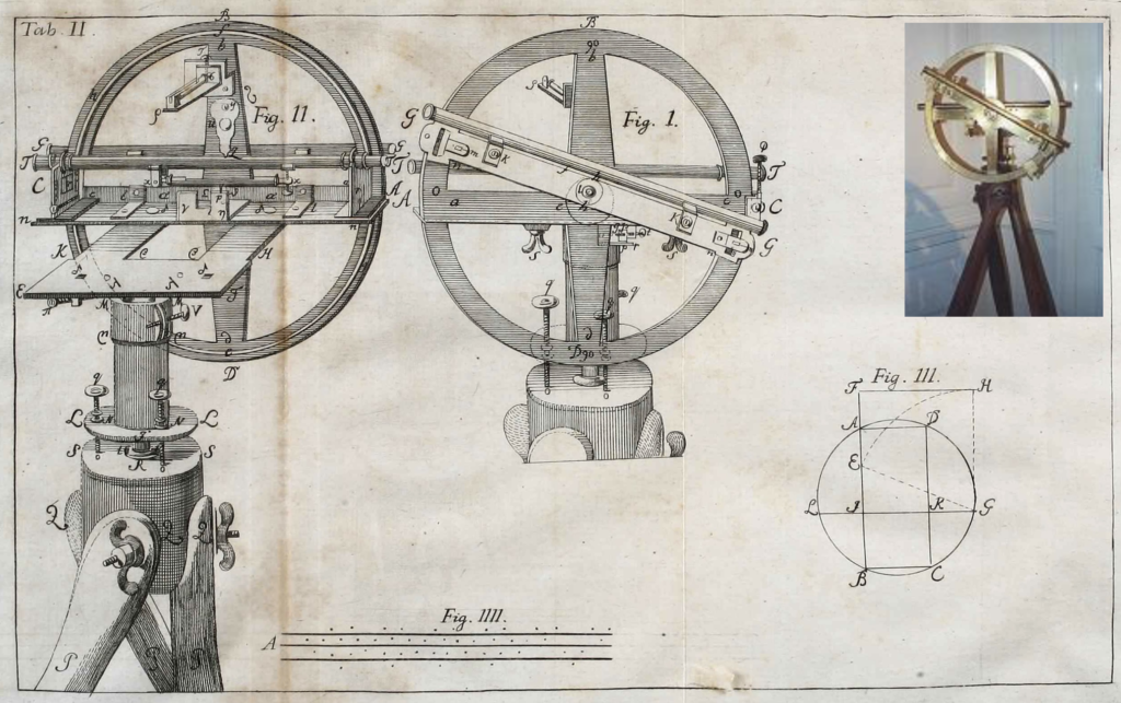
Planman’s instrument setup /1/
The Academy equipped Planman with state‑of‑the‑art instruments of the time. The key geographic instrument was an alt‑azimuth theodolite designed in 1750 to measure latitude. Daniel Ekström presented the device in the Royal Swedish Academy of Sciences publication “A new geographic instrument”.
The instrument includes a small telescope and scales for both azimuth and altitude. It has multiple spirit levels, numerous adjustment screws, and three nearly one‑metre‑long legs.
For geographic positioning, only the altitude measurement is used. In the image below you can see, in the centre, the altitude circle plate, onto which a 35 mm sighting tube is mounted. The tube contains two convex, adjustable lenses and a crosshair.
At both ends of the plate (G–G; width 45 mm, thickness 0.4 mm) are small apertures with 19‑division vernier scales. The circular plate—almost half a metre in diameter—has marks at each degree, and between degrees a third‑degree subdivision. In principle this allows a resolution of one arcminute.
From Planman’s data it can be verified that he was able to estimate the Sun’s altitude to about half an arcminute.
Determining latitude from the Sun’s altitude using declination
Before looking at Planman’s results, let us review the basics of measuring the Sun’s altitude—principles that also apply, for example, when measuring with a sextant.
Because Earth’s rotation axis is tilted by 23.4° with respect to its orbital plane, the Sun is directly “overhead” (at the zenith) only within the band between the Tropic of Cancer and the Tropic of Capricorn, depending on the season. Only at the equinoxes is the Sun on the celestial equator; then declination is zero and can be ignored.
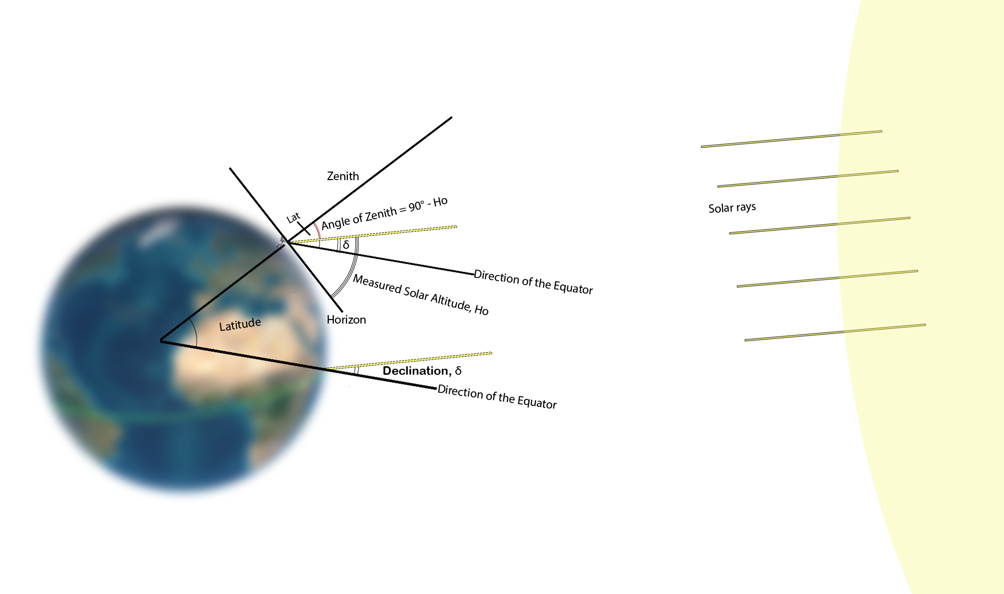
The angular offset of the Sun from the celestial equator is called declination, δ, and it must be taken into account when determining latitude. When the Sun is north of the equator, declination is positive; when it is south, declination is negative. Therefore, only at the equinoxes is declination exactly zero.
Declination values are published in calendars, and a reliable value can also be obtained from the U.S. NOAA service.
In latitude determination from the Sun, we use the complement of the Sun’s altitude: the zenith distance Hz = 90° − Ho.
When we measure latitude in the Northern Hemisphere and the Sun is due south above the equator, we obtain latitude as shown in the figure above.
Lat = Hz + δ = (90° − Ho) + δ
With negative declination, latitude is smaller than the altitude reading in the equation above.
Determining the Sun’s altitude
Even if the Sun’s altitude has been measured with an instrument, obtaining the correct result is not entirely straightforward. Let us go through the factors that affect the final value.
- Observed altitude (Ha): the angle you read directly from the instrument scale.
- Instrument calibration (Lk): the instrument’s small intrinsic error determined by manufacturer/user checking.
- Dip of the horizon (Hh): a correction that may be needed if the measurement plane (e.g., with a sextant) is above sea level.
- Refraction (R): the atmosphere bends light, making objects appear higher than they are.
- Parallax (P): a small correction because the observation is made from Earth’s surface, not its centre.
- Solar radius (Ar): a correction if the measurement point is not the Sun’s centre.
1. Solar altitude, Ha
The Sun’s altitude above the horizon (Ha) changes during the day and reaches its maximum at local noon. This maximum depends on latitude: the farther north you are, the lower the Sun is; the farther south, the higher it climbs.
Lines of latitude divide Earth evenly: there are 90 whole degrees in the Northern Hemisphere and 90 in the Southern Hemisphere. Historically, it was known that Earth’s circumference is about 40,000 km (21,600 nautical miles). Dividing by 360 gives about 60 nautical miles per degree and 1 nautical mile per arcminute. Correspondingly, one degree is about 111 km and one arcminute is 1,852 m.
Planman could therefore measure the Sun’s altitude with a precision of about half an arcminute—practically, just under a kilometre in latitude.
Measuring the Sun is not risk‑free: an urban legend claims that many captains ended up wearing an eye patch for the rest of their lives after damaging an eye in this context. A filter must therefore be used. Today we know that the Sun can be viewed only through special filters that block almost 100% of sunlight, but in the 1700s coloured lenses were used.
In Uppsala, a 1761 report /2/ states that with one telescope the glare could be reduced with a red filter glass, whereas with a green filter sunspots were less visible. With another telescope, they ended up using both red and green filters.
2. Instrument calibration, Lk
Instrument calibration is performed in several steps. Some adjustments may be made by the manufacturer when the user has no practical way to correct them. In any case, the user is responsible for a basic check before each use. With a sextant, mirror alignment and “zeroing” to the horizon must be checked. Often the instrument cannot be set to exact zero, and it returns an offset reading; the correction may be negative or positive.
For Planman’s instrument it was essential to confirm that all spirit levels were centred and all mountings secure. The publication does not state whether the maker performed calibrations, and I do not know the period’s exact practices.
3. Dip of the horizon, Hh
If the observer is above the horizon level, an amount must be subtracted from the altitude reading (in arcminutes):
Hh = 1.76 × h0.5 (where h is the observing site height in metres)
I was surprised to learn how significant the observing height (h) can be. For example, standing by the sea or a lake, h may be about 2 m, and the correction is already noticeable—about 2.5 arcminutes.
Planman’s theodolite is clearly superior for accurate latitude. Because it operates on a carefully levelled horizontal plane, it does not require a visible sea horizon, nor does it need a height‑of‑eye correction.
4–6. Total correction, Htotal
In tables—often in publications such as the Nautical Almanac—refraction, parallax and solar‑radius corrections are combined into a single “total correction”.
4. Refraction correction
Sunlight is refracted as it passes through the atmosphere, and the effect is corrected with the refraction correction, which is always negative. It depends strongly on the observed altitude (Ha). A simple and fairly accurate formula (for altitudes above 15°) in arcminutes is:
R = 1 / tan(Ha)
Because of the tangent behaviour, the correction grows rapidly below 15°, and atmospheric effects also increase the uncertainty at low altitudes.
5. Parallax angle correction
Because the observer is not at Earth’s centre, there is a small positive parallax correction relative to the Sun. In arcminutes:
P = 0.15 × cos(Ha)
Typically the parallax correction is about 10% of the refraction correction.
6. Measurement point correction
Placing the measurement point requires care. It is difficult to aim exactly at the Sun’s centre, so one often prefers the upper or lower limb. Even today, sextant users are advised to measure the horizon together with the Sun’s upper or lower limb. In that case, you must apply either a positive solar‑radius correction (upper limb) or a negative one (lower limb).
The Sun’s apparent diameter is a familiar half‑degree, so the radius is 15 arcminutes. Omitting it would therefore introduce a very large error—almost 30 km. However, Earth’s orbit is slightly elliptical, and as seen from Earth the solar radius (Ar) varies between about 15.8 arcminutes (July) and 16.3 arcminutes (January). This may feel like “splitting hairs”, but at worst a half‑arcminute difference still means almost a kilometre in latitude.
Once you know the principle, you can estimate the correction roughly, but you can also compute it in arcminutes using:
Ar = 16.05 × (1 − 0.01672 × cos(0.9856 × (day − 4)))
Here day is the running day number counted from the start of the year. In practice, astronomers used ready‑made tables; the formula simply shows how the value is computed in principle.
Combining the previous three corrections gives the desired total correction:
Htotal = −R + P ± Ar
If you prefer a table instead of calculations, the total correction is given separately for the Sun’s upper and lower limbs.
Summary of altitude measurement
Therefore, the true solar altitude above the horizon is:
Ho = Ha ± Lk − Hh + Htotal
It is important to realize that to obtain the correct altitude, you should not focus only on the instrument’s scale resolution: in defining the observing conditions it is easy to introduce errors that are several times larger.
Planman’s measurement results
In the Royal Swedish Academy publications, Planman reported separately the latitude results for Kajaaninlinna and for Oulu. I would have liked to verify the results in more detail, but the publications did not list all the corrections mentioned above. The declination correction is treated as self‑evident in his text, and I have not even found a mention of which table was used.
In addition, refraction and parallax corrections are mentioned at times, but they refer to contemporary tables without a precise citation. He did not need a height correction for the observing site because the altitude instrument was levelled to the horizontal plane.
Latitude of Kajaaninlinna /3/
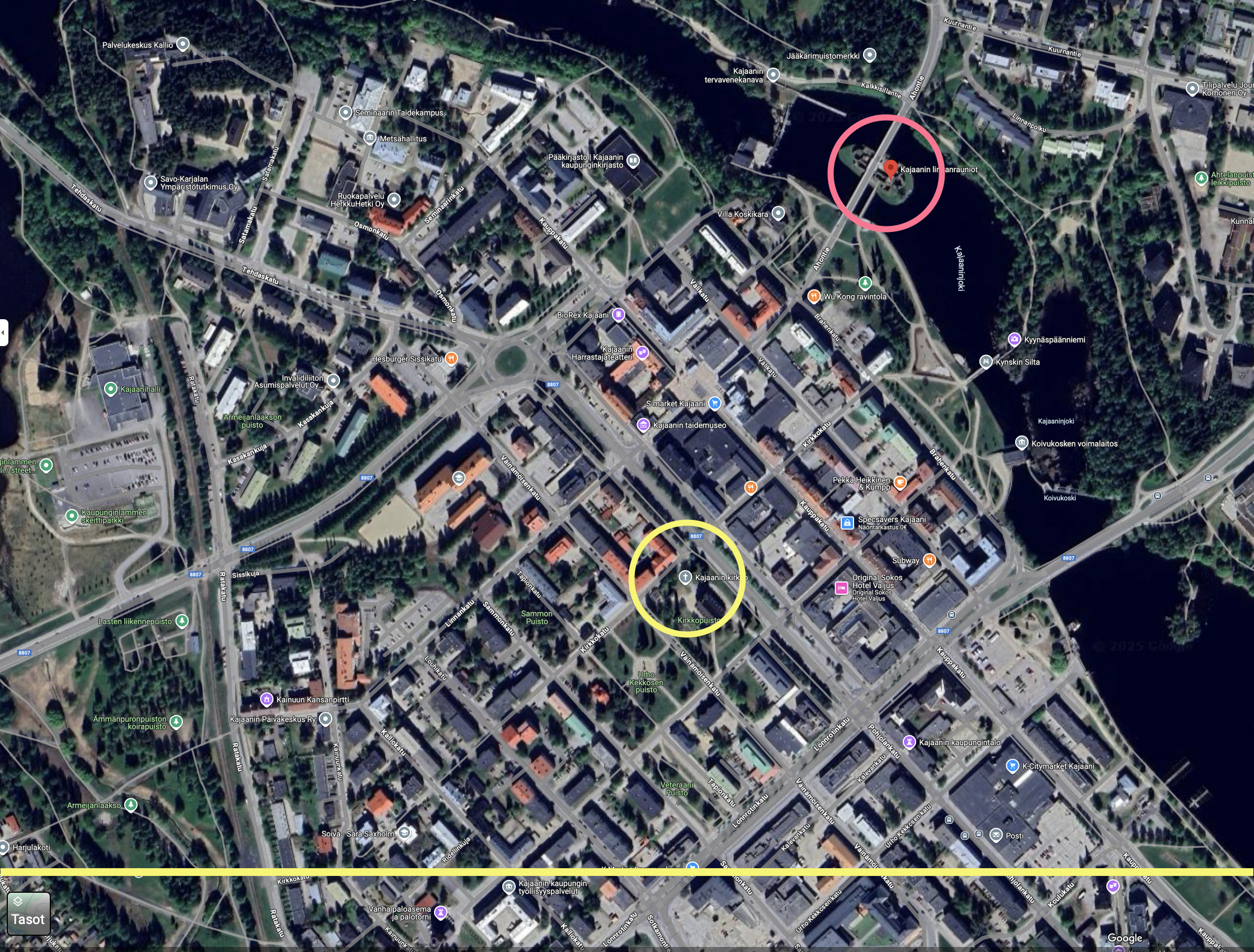
Correction 23 Jul 2023 — Because Planman spoke of Kajaaninlinna, I assumed he meant the castle itself. But the castle had been destroyed decades earlier, and when I looked more closely, the instruments were placed at the bell tower near the church. Kajaani’s three churches have been at the same location, so after a re‑check Planman’s line of sight was even more accurate.
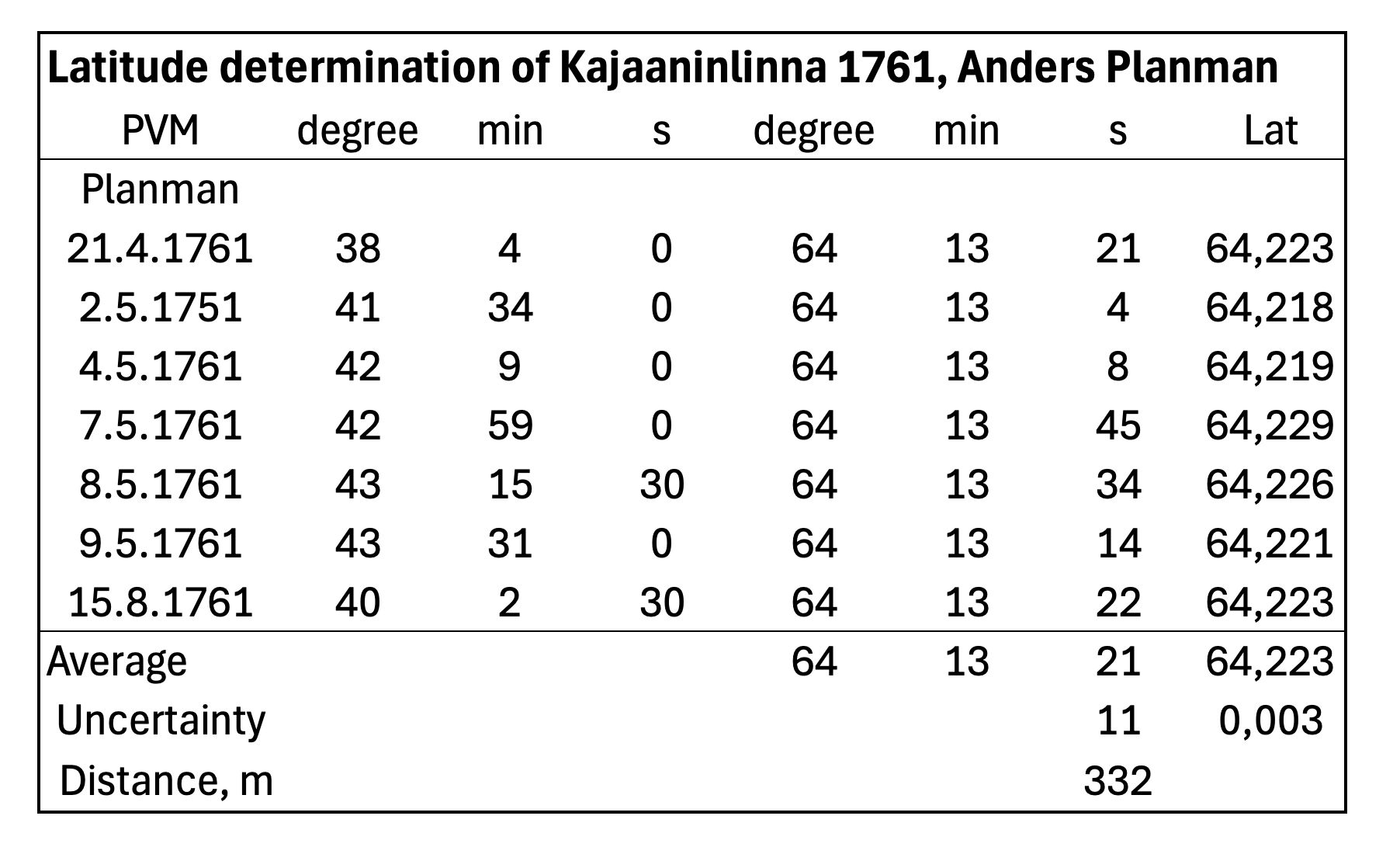
Seven measurements were made between late April and mid‑August. With seven measurements, Planman’s result becomes more precise. Using the standard deviation, the 95% uncertainty is ±11 arcseconds, corresponding to ±332 metres.
The exact modern latitude of Kajaaninlinna is 64° 13′ 45″, so compared to that Planman’s result lies 24 arcseconds (740 m) to the south. However, Planman rounded the mean to half an arcminute, and in this case the rounding reduces the difference by 8 arcseconds: he reported 64° 13′ 30″.
A supporting argument for Planman’s rounding was also the altitude of Arcturus at upper culmination, measured on two nights in May as 46° 14′, which yields the same latitude for Kajaani: 64° 13′ 30″. I was able to confirm the general direction of this result with Stellarium.
Planman checked his measuring instrument very carefully and no adjustments were needed. The equipment was also stored very safely. In his publication Planman notes that a previous latitude value from 1758 had been 16 arcminutes (about 30 km) too large; that earlier measurement was made by French surveyors for a map of Europe.
Latitude of Oulu /4/
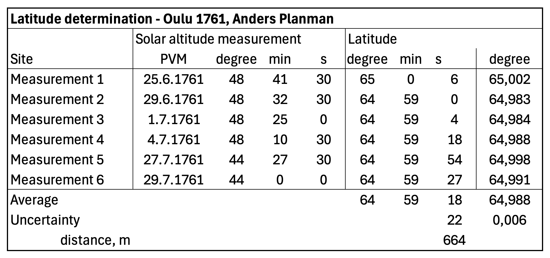
Planman measured Oulu’s latitude six times over about one month. The scatter of the measurements was twice that of Kajaaninlinna. The uncertainty is ±22 arcseconds, which corresponds to ±664 metres.
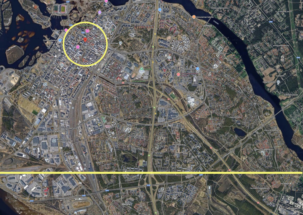
The publication does not give an exact location, and it is not entirely clear where Planman measured. Because moving the equipment was surely avoided, I use as a default the old vicarage of Oulu on Asemakatu, at latitude 65° 0′ 49″. If he observed from the vicarage, Planman’s reported position is 1.5 arcminutes (about 2.8 km) to the south.
An interesting aspect of this publication is that Planman published it only in 1767—six years after the measurements. Perhaps he was preparing for the coming 1769 transit of Venus campaign.
Other localities
In addition to the Kajaaninlinna measurements, between April 1761 and January 1762 Planman measured the coordinates of Finnish localities requested by the Academy. He measured the latitude of 11 other locations, as shown in the table below, to which I added a comparison with Google Maps data. In his 1767 article he, for some reason, omitted the Sun’s altitude for several locations and reported only the latitude.
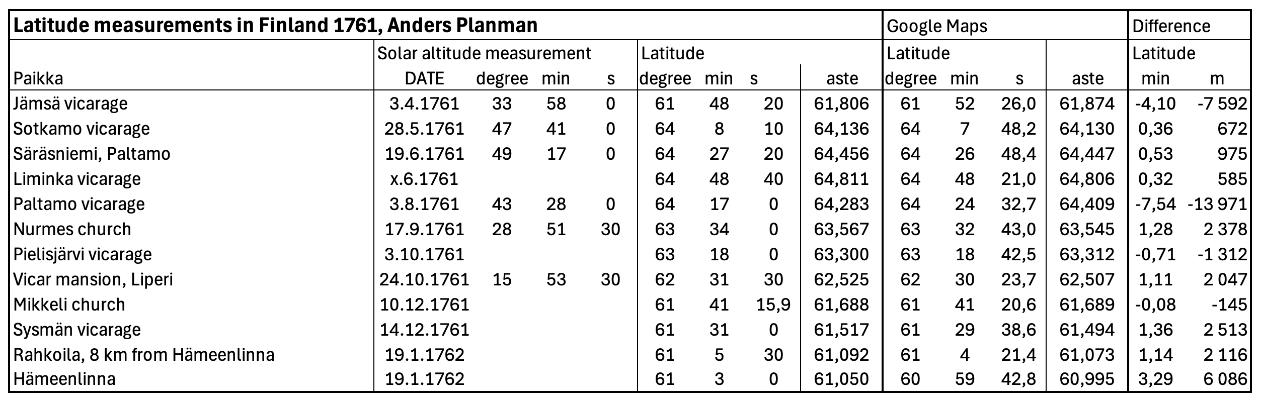
The results show clearly how strongly the number of measurements affects the outcome. Planman does not say whether he made multiple measurements at each place, but these results are all weaker than in Kajaaninlinna or Oulu. Additional error may also come from the difficulty of verifying the exact measurement site.
For three locations the difference is under one kilometre; for four it is under three kilometres; for three it is 6–8 kilometres; and for one location the difference is almost 14 kilometres.
Summary
Although the latitude differences in Planman’s plots may look significant, the results are truly accurate. The statistical uncertainty is smaller than the smallest division of the instrument. Even if the absolute difference to modern values is larger, establishing the “true” reference for the exact historical site after 260 years is not necessarily easy.
Planman reported to Sweden in Swedish, but his dissertation and other reports were written in Latin, which in the 1700s served as an international language of science.
I have found it astonishingly interesting to read 18th‑century scientific publications. I was surprised by the accuracy of the measurements and by the care taken to obtain the best possible result.
(Other localities added 19 Jul 2025)
Sources
[1] Ekström, Daniel. Et Nyt Geografisk Instrument, Kungliga Svenska Vetenskapsakademiens Handlingar, Januari, Februari och Mars i år 1750, pp. 26–44.
[2] Wargentin, Pehr (ed.). OBSERVATIONER På Planeten Veneris gång genom Solens Discus, om äro gjorde i Stockholm, Upsala, Åbo, Carlscrona, Lund, Landscrona, Cajaneborg den 6 Junii 1761. Kungliga Svenska Vetenskapsakademiens Handlingar, April, Maj och Juni i år 1761, pp. 143–166.
[3] Planman, Anders. Cajaneborgs geografiska belägenhet, Kungliga Svenska Vetenskapsakademiens Handlingar, April, Maj och Juni i år 1762, pp. 132–139.
[4] Planman, Anders. Astronomiska observationer under resan til och ifrån Cajaneborg, gjorde år 1761. Kungliga Svenska Vetenskapsakademiens Handlingar, Januari, Februari och Mars i år 1767, pp. 132–139.