In Yle Areena’s 2015 podcast series History of Astronomy, Tapio Markkanen mentions that in 1761 and 1769 Anders Planman, a professor at the Royal Academy of Turku, travelled in Finland to observe the transits of Venus and, in connection with those expeditions, determined the geographic coordinates of several localities.
I previously wrote about measuring a locality’s latitude 260 years ago. Here we look at the contemporary way of determining longitude. Later in the summer I also planned to add an article about the transits of Venus in the 1760s.
The greatest challenge in measuring a locality’s longitude in the 1760s was obtaining the local time accurately. In maritime navigation, uncertainty in timekeeping led every year to losses of ships and lives, and it was not simple on land either.
Determining longitude
Longitude runs from pole to pole, and the 0° meridian (the prime meridian) passes through Greenwich in the United Kingdom.
Meridians meet at the poles, so the distance between them decreases as you move away from the equator. Only at the equator does a one‑degree difference in longitude correspond to 60 nautical miles (about 111 km).
Because of Earth’s rotation, the Sun appears to move across the sky at 15 degrees per hour. This link between longitude and time is the basis of time zones. For that reason, in the 1700s—before a single universal prime meridian—new longitudes were often stated as a time difference relative to a known place.
When moving north or south, a one‑degree longitude difference no longer corresponds to 60 nautical miles. In Finland, near Helsinki, one degree of longitude corresponds to about 30 nautical miles. In general, the east–west distance between two meridians at a given latitude is obtained by multiplying the equatorial distance (60 nautical miles per degree) by the cosine of that latitude.
Determining longitude requires an observation of a known celestial event and a very accurate clock. Even small timing errors can translate into a longitude error on the order of nautical miles. Planman used several different observing methods and had a very accurate clock, which was handled with extreme care.
Checking the Pendulum /1/
On his expeditions in 1761 and 1769, Planman had “an astronomical clock, made by the excellent craftsman ERNST in Stockholm and equipped with a pendulum assembled from brass and iron rods”. The pendulum remark refers to a compensation pendulum (a gridiron pendulum) built from multiple parallel brass and iron rods—cutting‑edge technology of its time. John Harrison had developed this approach about four decades earlier to reduce temperature‑driven changes in pendulum length, which made the clock remarkably accurate.
“These instruments were moved on 30 May to the bell tower, from where a freer view opened to sunrise and sunset. The clock was placed in the lower part of this building, in the most stable and solid place possible, and moreover protected by such strong locks that no one had access without the DIRECTOR’s knowledge. And to ensure that not the slightest suspicion of vibration would arise, care was taken that on the day of the Sun no signal was given to the temple unless the bell‑tower clock was struck lightly three or four times.”
These precautions—stable placement, locks, and restrictions on bell ringing—show extraordinary care.
Measurement results
The pendulum‑clock checking calculations were a delight to read, because all essential ingredients are present. With them Planman demonstrates convincingly that local mean noon is determined accurately. The calculations also use the rarely seen tersi ('''), which is 1/60 of a second.
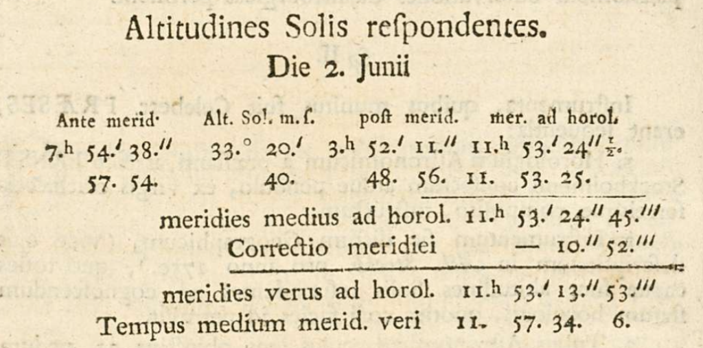
This 255‑year‑old table is an elegant demonstration of how an 18th‑century astronomer used simple geometry and careful repetition to reach astonishing precision in determining local time. It is raw data that attests to the quality of his work.
For closer inspection I also present the entire calculation table translated. Because the clock is checked using the Sun at local noon, it cannot be done on an overcast day. Planman anticipated this and performed checks daily. Conditions were relatively favourable: only on the day of the Venus transit did he fail to measure noon directly.
However, the results from 2 June, 4 June and 5 June saved the situation. In my reproduction of the table, the row for 3 June has a grey background because it is based on interpolations I computed from the surrounding days.
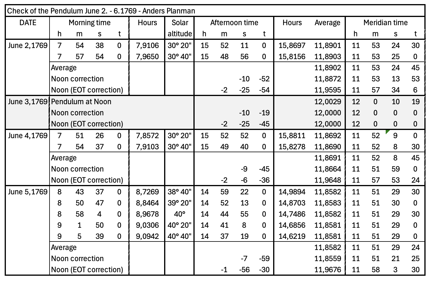
Because the Sun’s meridian altitude changes only very slowly, the instant of true noon was determined by timing equal solar altitudes many hours before and after noon—here at 33° 20′ and 33° 40′. For each altitude an average time was computed, and on 2 June the two altitudes differ by only 0.5 seconds. Since the pendulum clock gave time only to the nearest second, the scatter is essentially as small as it can be.
Even that average was not sufficient for Planman, because by 1769 it was known that the Sun’s daily arc is not perfectly symmetric around noon: solar declination changes continuously as Earth moves along its orbit. Therefore Planman applies a “noon correction” for each day. In early June, near the summer solstice, the Sun’s motion is slightly faster in the afternoon, so true noon occurs a little earlier than the simple average. Because the solstice (where the declination trend reverses) is near, the correction is only a few seconds—and in the table we can see it decreasing day by day. The result for each day is the clock’s measured local noon.
Earth’s orbit also creates the need for the equation of time (EOT). In early June it is a few minutes negative, approaching zero near the summer solstice. The equation of time is subtracted from the clock’s noon value relative to 12:00:00 to obtain local mean noon.
After that Planman computed, for each day, the difference between the clock and local mean noon:
- 2 Jun 1769: difference is 4 minutes 20 seconds and 13 tertiae
- 4 Jun 1769: difference is 5 minutes 54 seconds and 24 tertiae
- 5 Jun 1769: difference is 6 minutes 42 seconds and 5 tertiae
The essential point is that although the clock’s displayed time did not stay “on time”, Planman’s measurements show that the pendulum mechanism kept the rate of slowing stable: 47 seconds 21 tertiae ± 36 tertiae. From this he could compute that the true noon of 3 June, in the clock’s time, was accurate to about half a second: 11h 52′ 36.16″.
Planman’s published table and the follow‑up computations demonstrate how an 18th‑century astronomer used simple geometry and careful repetition to reach remarkable precision in local time determination. This raw data attests to the quality of his work.
Planman’s telescopes
The sizes of the expedition telescopes look enormous to today’s amateurs. The party carried three telescopes, although the achromatic instrument was replaced by another in 1769.
- For the transit of Venus, an astronomical telescope with focal length 21 Swedish feet (6235 mm) and an eyepiece of 2.9 Swedish inches (72 mm), giving a magnification of about 87×. One can only imagine the challenges both in transport and use. The long focal length was a way to reduce chromatic aberration in early refractors.
- For planets and stellar measurements, an astronomical telescope with focal length 6 feet (1782 mm), equipped with a micrometer (an adjustable crosshair).
- Most modern were achromatic refractors. In 1761 the expedition received a new double‑lens telescope made by John Dollond: a “shorter” tube with reduced colour errors. Its focal length was 5.5 feet (1633 mm) and it was made after 1758. In 1769 the telescope was replaced by a smaller one with focal length 3 feet (891 mm) and an eyepiece of 22.3 mm, yielding about 40× magnification.

Planman’s longitude measurements
Because the transits of Venus occurred in 1761 and 1769, Anders Planman made two expeditions. In 1761 the original plan was to travel as far as Lapland, but the winter had been exceptionally snowy and he chose Kajaani as his observing site. Apparently conditions were satisfactory, because in 1769 the expedition again went to Kajaani.
Kajaaninlinna longitude in 1761 /2/
Planman arrived in Kajaani well before the transit of Venus. Before the main event there would be both a lunar and a solar eclipse, during which he made his first latitude measurements. Later in the autumn, after returning from a tour of Finland back to Kajaani, he also checked longitude using the eclipses of Jupiter’s moons.
Method 1: Lunar eclipse, 18 May 1761
In a lunar eclipse Earth’s shadow moves across the Moon’s surface. The eclipse is seen on Earth at exactly the same moment for all observers. By comparing the times when specific lunar features (e.g., Grimaldus, Aristarchus, Mare Crisium) enter or leave the shadow in Kajaani and in Stockholm, one can determine the time difference between the places—and thus the longitude difference.
During the immersion phase Planman followed the covering of lunar craters in great detail. He used a refractor equipped with a micrometer and collected 26 observations during the lunar eclipse. Looking at the list gathered over about 80 minutes, my respect for the professionals of that era only grows.
During totality clouds intervened and Planman could not follow the brightening of the Moon, but he still obtained two observations soon after brightening began. Then there was a one‑hour gap, and during the last four minutes he recorded two more observations.
He compared the mean time difference of the 25 clearest observations with corresponding observations made at the Stockholm Observatory and concluded that Kajaaninlinna lies 38 minutes 40 seconds east of Stockholm Observatory.
Method 2: Solar eclipse, 3 June 1761
Using a solar eclipse is a more complicated way to determine longitude, because the Moon’s shadow sweeps across Earth’s surface. In practice the end of the eclipse is usually the easiest moment to time precisely.
At Kajaani’s latitude, a 5/6 partial eclipse was seen and Planman recorded the end time at Kajaaninlinna. He compared this with an observation by Anders Hellant in Tornio. After accounting for parallax between the locations, he obtained a Kajaani–Tornio time difference of exactly 14 minutes. Tornio–Stockholm was known to be 24 minutes 38 seconds, so by this method Kajaaninlinna–Stockholm becomes 38 minutes 38 seconds.
The result matches the lunar‑eclipse result well. A closer analysis, however, shows Tornio’s longitude was 20 seconds farther west. This was noticed in 1769, when the Uppsala astronomer Fredric Mallet re‑checked Hellant’s measurements /3/. This correction introduces an additional 20‑second error, so the solar‑eclipse longitude estimate based on Tornio was not fully successful either.
Method 3: Eclipses of Jupiter’s moons, September 1761
In the early 1600s Galileo Galilei proposed that the regular disappearances and reappearances of Jupiter’s moons from the planet’s shadow are universal time markers, and therefore provide a way to check time.
The method was especially desired for navigation at sea, where ships were lost regularly, but it was not practical on rocking vessels. It took about 150 years before a sufficiently accurate marine chronometer solved the problem.
On land, however, the method could reach moderate accuracy and was much faster than triangulation—especially with the telescopes and clocks of the time. Planman performed longitude check measurements twice in September 1761.
On 3 September 1761 Planman observed Ganymede disappearing into Jupiter’s shadow with the 21‑foot telescope. He compared his timing with an observation by Anders Hellant in Tornio using a similar telescope and obtained a Kajaani–Tornio time difference of 14 minutes 19 seconds—only two seconds off the correct value. Hellant had succeeded well this time. But when Planman added the (then) erroneous Tornio–Stockholm offset, Kajaaninlinna’s distance from Stockholm became 38 minutes 57 seconds.
On 8 September 1761 Planman observed an eclipse of Io. He compared his timing with an observation made in Marseille and obtained a time difference of 1 hour 28 minutes 35 seconds. The Marseille–Stockholm offset was known as 37 minutes 54 seconds, and by this route the Kajaaninlinna–Stockholm value became 37 minutes 54 seconds. Planman was not satisfied with this measurement, because Io was near the horizon in Kajaani while in Marseille it was higher and more clearly visible.
From these two measurements Planman obtained an average of 38 minutes 26 seconds.
A small interlude
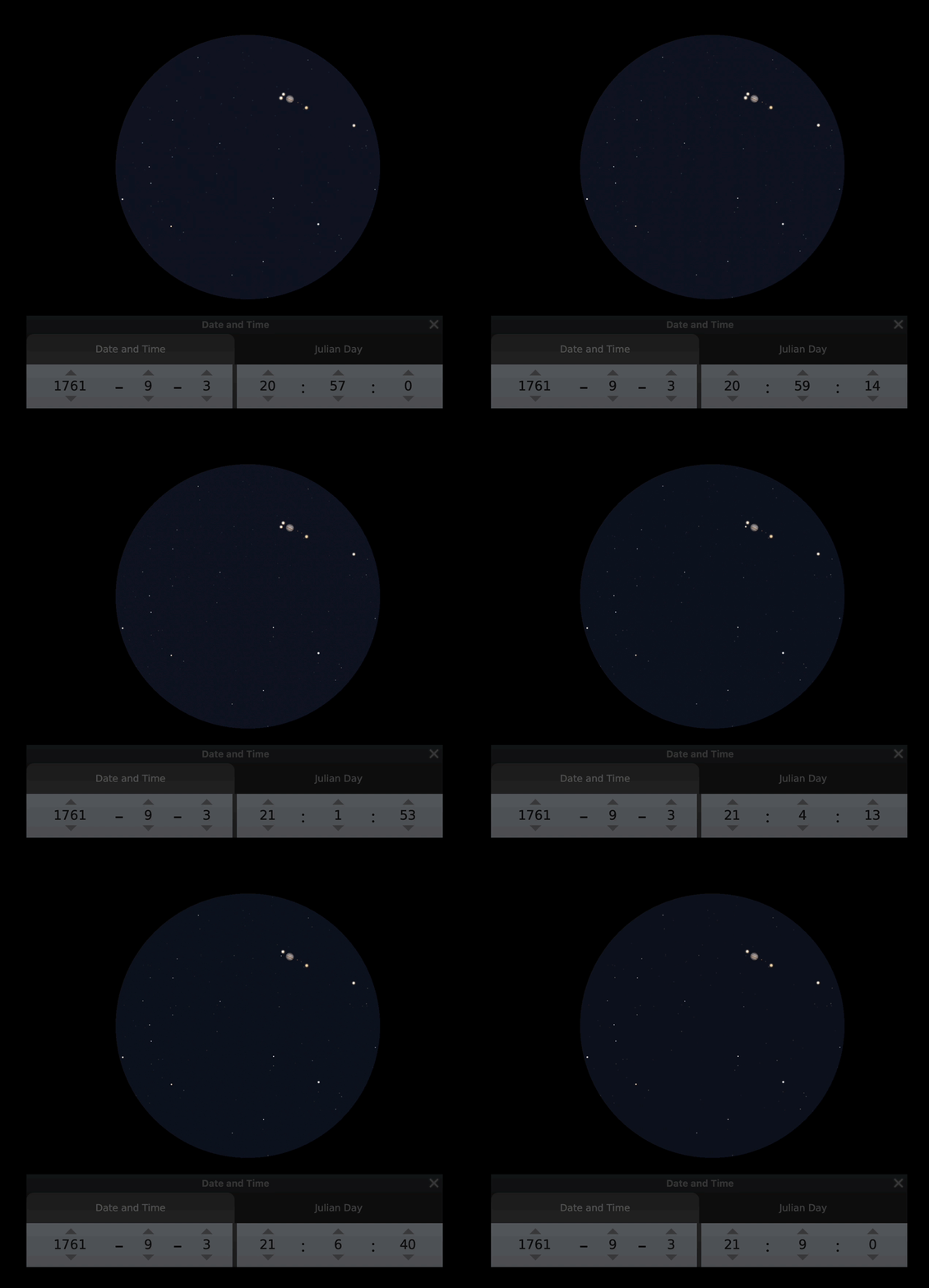
Before judging the amateur astronomer Hellant too harshly, here is an animation of what the 3 September observation looked like. You can judge for yourself how precisely one can time the phenomenon. The animation was made with Stellarium; the roughly 50 minutes of the event are sped up to 25 seconds.
Summary of the Kajaaninlinna measurements
Planman obtained somewhat contradictory results, but he performed excellently when judged in hindsight. Careful observing and good equipment made accurate measurement possible.
After weighing the measurements (pun intended), Planman emphasized the many observations from the lunar eclipse and reported Kajaaninlinna’s offset from the Stockholm Observatory as 38 minutes 40 seconds. According to Google Maps, this differs as a “clock distance” by only two seconds!

Planman also notes that earlier longitude determinations for Kajaaninlinna were too far east: in 1747 the measured longitude was 25 minutes (about 20 km in a Swedish map), and in 1758 it was 8 minutes (about 6.5 km in a map of Europe).
An interesting detail is that in the Academy’s promptly published summary of Sweden’s transit‑of‑Venus results, Planman’s 18 May 1761 longitude measurement is mentioned, but the summary gives the value as “about 39 minutes 20 seconds” /4/.
Planman corrected one timing mistake related to the Venus transit in his article published a year later on Kajaaninlinna’s geographic position. But he does not address the above longitude value, even though none of his measured results exceeds 39 minutes. Perhaps the summary relied on preliminary estimates?
In any case, history shows the final published result is accurate, so there is no need for further concern.
Longitudes of Finnish localities /5/
Measuring longitude at other localities was harder than measuring latitude, because pre‑known, tabulated celestial events were much rarer than the Sun’s daily motion. If the weather did not cooperate at the critical moment, Planman may not have had time to wait for better conditions. As a result, besides Kajaaninlinna he managed to determine longitudes for only five localities. Even Hämeenlinna’s value, as with latitude, was based on Rahkoila’s measurements.

The Rahkoila measurement is the only one that is reasonably accurate. In Liperi, the largest error may be due to Planman falling ill, because the measurement was carried out by the assistant pastor Lyra following instructions. Planman notes in his article: “I had, however, earlier told both my companion and the assistant pastor, Mr. Lyra—who was glad to follow me here— how they should proceed in observing the emersions of Jupiter’s moons.”
Planman’s observing sites are described clearly in the style of the time, but parsonages, churches and the like may have moved over 260 years. This is not the case for Mikkeli’s church, because we know the wooden church of that era was built in 1750 on the site of today’s market square.
Therefore it is possible that at some observing sites Planman did not stay long enough to verify the accuracy of his pendulum clock. In that case, to explain the discrepancies, the timing would need to contain about a 1.5‑minute error in Mikkeli and in Pielisjärvi.
On the other hand, the latitude measurement in Mikkeli was very successful, so a systematic clock error does not feel logical. That leaves the timing of the phenomenon itself as the likely source of error. As the animation above shows, the disappearance of a Jovian moon is abrupt, and the next suitable event may have to be waited for—at the mercy of the weather—from a couple of days to a week.
It is also possible that the published tables of Jupiter‑moon events contained some error, although we know that the Academy’s secretary Pehr Wargentin had been monitoring the Galilean moons regularly since the early 1740s /6/.
Based on the comparison presented, Planman’s longitude results were for the most part only mediocre.
Using AI as a research aid
This summer project exceeded my early hopes to understand how geographic positioning by astronomy worked in the 1760s. Interest often leads one into a deeper and deeper rabbit hole, and for my part I found AI to be an excellent tool.
Using it is clearly a “technical sport”: you should try to frame queries clearly and define the expected quality level. The work can be very challenging .
Still, I progressed much further in the investigation because AI also surfaced clear information that I likely would not have encountered otherwise. Knowledge grows step by step.
Over time, the AI interface has some irritating traits. Its almost floor‑bowing habit of apologizing can be funny at first, but when the problem still does not move forward, the smiles fade. Another annoyance is excessive flattery—especially of the user’s thoughts and self‑found facts. I also do not always find the right way to prevent invented “facts”, which can easily hide among real ones. And even if you ask the AI to admit it does not know, it usually will not—because it does not know that it does not know.
Balancing these experiences are positives: you get small nuggets from various directions about loosely connected matters, from which it is good to begin stitching facts together. In this case, things started to roll in earnest once the AI translated a Latin article.
It also took time to understand that AI cannot open and read links; it answers correctly only if the relevant text was included in its training. For this reason the sources recommended by the AI often do not work.
Because the AI found relevant passages across all used sources, those over‑250‑year‑old publications must also have been included in its training material.
And the most important thing is to check everything you learn from such collaboration.
[1] Planman, Anders. Expositio observationum transitus Veneris per solem, Cajaneburgi a:o 1769 D. 3 Junii factarum, Carl Widqvist’s master’s presentation, Royal Academy of Turku 1770. (In the 1700s, a master’s degree involved presenting a dissertation written by the professor.)
[2] Planman, Anders. DISSERTATIO DE VENERE IN SOLE VISA DIE 6 JUNII ANNI 1761, Planman’s dissertation, 23 Feb 1763, Royal Academy of Turku, 1763.
[2] Planman, Anders. Cajaneborgs geografiska belägenhet, Kungliga Svenska Vetenskapsakademiens Handlingar, April–June 1762, pp. 132–139.
[3] Pekonen, Osmo. The Amateur Astronomer Anders Hellant and the Plight of his Observations of the Transits of Venus in Tornio, 1761 and 1769. Journal of Astronomical Data, 2013.
[4] Wargentin, Pehr. OBSERVATIONER På Planeten Veneris gång genom Solens Discus... Kungliga Svenska Vetenskapsakademiens Handlingar, April–June 1761, pp. 143–166.
[5] Planman, Anders. Astronomiska observationer under resan til och ifrån Cajaneborg, gjorde år 1761. Kungliga Svenska Vetenskapsakademiens Handlingar, January–March 1767, pp. 132–139.
[6] Kärnfelt, Johan. ‘Excellentissimo tubo Dollondiana’: The Stockholm Observatory’s 10-foot Dollond achromatic refractor, Journal of the History of Astronomy, Vol. 5, Issue 1.